January 2024 Seasonal Outlook
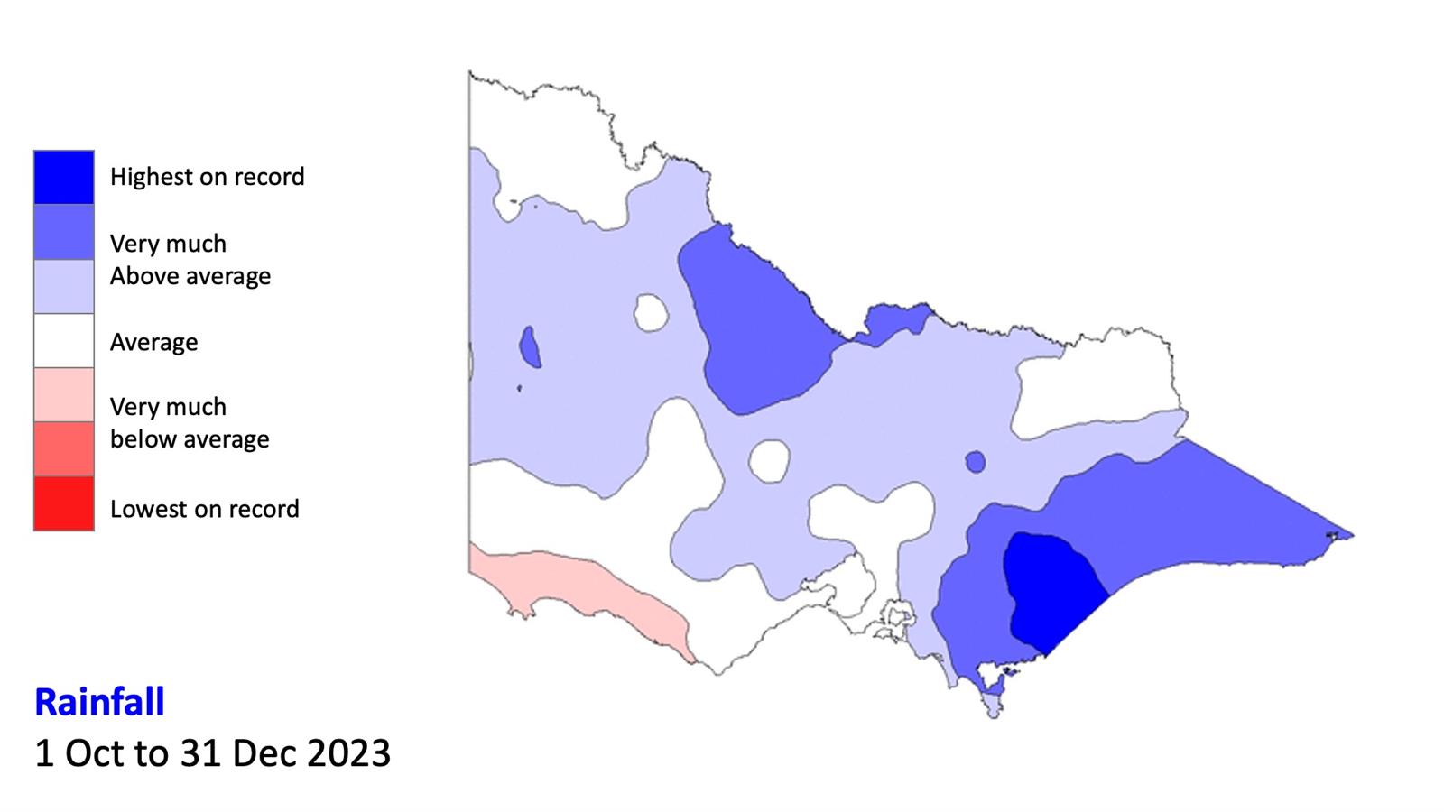
 Rainfall: 1 Oct to 31 Dec 2024
Despite being in the El Nino and Positive Indian Ocean Dipole, which is typically very dry, rainfall during October to December 2023 was well above-normal across much of Victoria.
CFA Fire Behaviour Analyst Tom Sanderon provides the latest monthly seaonal outlook.
Transcript:
Hello, I’m Tom Sanderson, IT Infrastructure and Operations Manager and Fire Behaviour Analyst at CFA, and here's the January update of the Summer Bushfire Outlook.
Despite being in the El Nino and Positive Indian Ocean Dipole, which is typically very dry, rainfall during October to December 2023 was well above-normal across much of Victoria, particularly in the north and in Gippsland.
This is likely due to record warm global sea surface temperatures as well as the southward shift of weather patterns bringing more tropical moisture down to Victoria
During January tropical moisture drawn down from northern Australia has resulted in significant rainfall and flooding in central and northern Victoria.
The first nine days of January had set the record for the wettest start to the year in Victoria since records began around 1900. Parts of Victoria have recorded three times January average rainfall, but there are pockets such as the Otways and that are below the average rainfall for January.
The high rainfall has resulted in very much above average soil moisture in most areas resulting in catchments being saturated and many water storages that are close to capacity. This will mean forests right across Victoria will generally have lower potential for bushfires.
Most grasslands and croplands in North West and West regions are in the dry phase of curing. This extends into North East region and even parts of South West region.
Due to the recent rain and good soil moisture, we have seen grass start to green up and this has led to lower incidents of grassfires.
In December, grass and scrub incidents have been below the long term average in all regions except the north West which has been closer to the long term average
For the season thus far, North West region is running at between 500 and 5,000 ha cumulative area burnt, while other regions remain less than 500ha, with the exception of South East where large early-season bushfires occurred in Sept.
During December approximately eight hundred hectares was burnt most of this was in the North East and North West.
The Fire Danger Period is in place in all municipalities across Victoria.
Looking forward, for the period February to April 2024, it is likely that maximum temperatures will be warmer than average.
Following a wet January, it is expected that February to April will be average to drier than average particularly in the north and west.
In summary, heavy rainfall in early summer has reduced fire potential across Victoria, particularly in forests, however grasslands and drier woodlands and heathlands may rapidly dry out to a flammable condition with the onset of hot and dry weather.
Victoria is expected to see a return to warmer and drier conditions February to April.
Therefore, Bushfire risk is likely to increase in this late summer period, particularly in the north and west of the State, while forests in the east may remain damper for longer.
Wherever you live, work or travel, now is the time to have a conversation with your family, friends and neighbours about what it means to live with fire. What can you do, to be more prepared for this bushfire season?
| Submitted by |
CFA Predictive Services |